
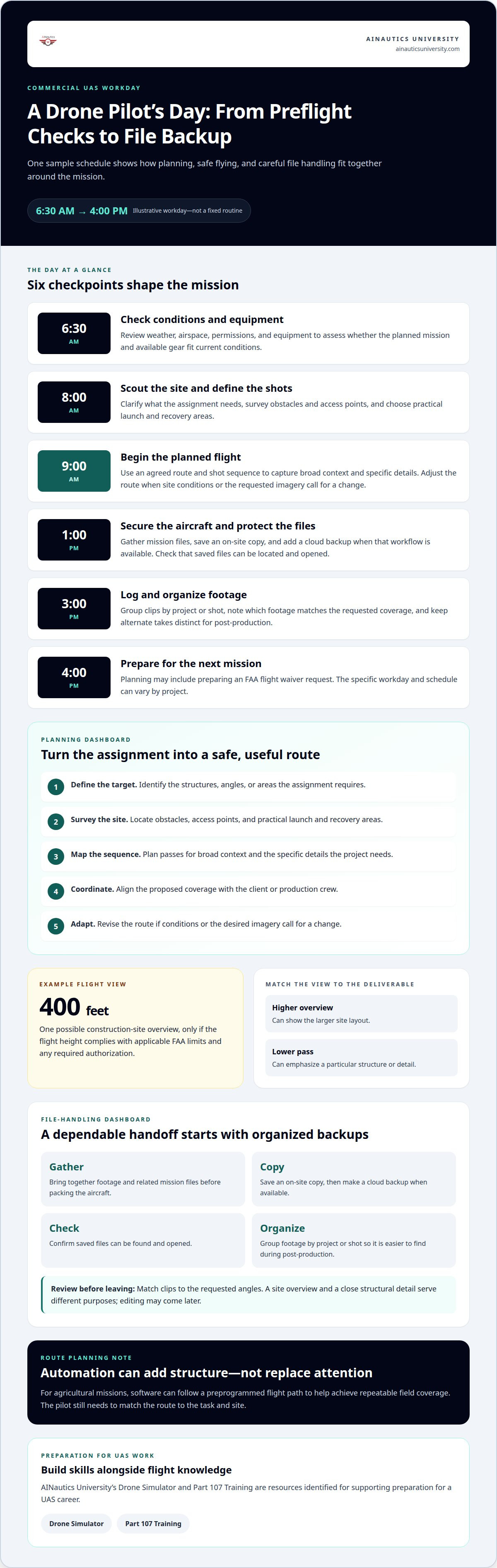
The flight is only one part of the work. A day in the life of a commercial drone pilot includes preparing for a mission, checking weather and airspace, planning a safe flight, and confirming that the images or data meet the assignment’s needs. Commercial drone pilots remotely operate aircraft for work such as photography, inspections, construction monitoring, and mapping.
It’s easy to picture a pilot spending the whole day at the controls, but the job also involves planning, judgment, and careful file handling. This overview follows a typical workday, from preflight checks to reviewing and backing up footage.
You’ll see how pilots prepare equipment, assess conditions, coordinate on-site, and adapt as a mission unfolds. Details vary by project, but understanding the workday can help students, families, and educators explore whether a UAS career might suit them.
Key Takeaways
- See how weather, airspace, permissions, and equipment checks shape a pilot’s preparation before a mission.
- Learn why on-site scouting and a planned flight path help align the flight with the project’s needs.
- Understand how reviewing footage before leaving can reveal whether a shot needs another take.
- Discover why organizing and backing up files are important parts of wrapping up a drone job.
- Explore how the Drone Simulator and Part 107 Training can support preparation for a UAS career.
On-site scouting and flight-path planning
At 8:00 AM, a commercial drone pilot may arrive at a worksite to scout conditions and shape the mission plan. The first step is understanding what the client needs captured, whether that means a construction overview, a roof inspection, or a sequence for a production crew. The pilot then studies the site from the ground before choosing where to launch and what the aircraft needs to show. A planned route connects the requested images to the space available for safe operation.
Scouting helps turn a broad assignment into a practical flight. The pilot looks for obstacles, identifies important features, and considers how the aircraft can approach each subject. For a construction project, one possible shot is the site from 400 feet in the air, provided the flight height complies with applicable FAA limits and any required authorization. That view may show the larger layout, while a lower pass can emphasize a particular structure. The route and camera angle depend on the deliverable, the site, and the conditions present that day.
Coordination starts before takeoff. A pilot may review the route and shot list with a client or production crew to make sure everyone understands the planned coverage. When a project calls for several views, planning a sequence is more effective than improvising each pass. A site overview, for example, can establish context before closer images focus on a roofline, work area, or structural feature. A good plan also allows for adjustments if the site differs from expectations.
- Define the target: Identify the structures, angles, or areas the assignment requires.
- Survey the site: Locate obstacles, access points, and practical launch and recovery areas.
- Map the sequence: Arrange planned passes to capture broad context and specific details.
- Coordinate: Align the proposed coverage with the client or production crew.
- Adapt: Revise the route if site conditions or the desired imagery call for a change.
For agricultural missions, a planned route can help achieve repeatable coverage across a field. The Nebraska Corn Board notes that agricultural drones can use software to follow a preprogrammed flight path. The pilot still needs to match that route to the task and site. Automation provides structure, but it doesn’t replace attention to the mission’s requirements.
A sample workday places the first takeoff at 9:00 AM, after the 8:00 AM site visit and planning. The pilot may reshoot an angle to match the light or change lenses to highlight a specific detail. At 4:00 PM, planning the next mission can include preparing an FAA flight waiver request. These times illustrate one possible schedule, not a fixed routine. Scouting and flight planning turn the assignment into a sequence of deliberate decisions, with the route serving the project rather than the other way around.
Packing up and backing up footage
At 1:00 PM, one example workday moves from flying to wrap-up. The pilot secures the aircraft and gathers the mission’s files for backup. A copy on-site gives the team access to footage before leaving the location. A second copy in the cloud adds another place to retrieve the files. This step matters because captured images and data are the project’s deliverables, not just a record of the flight.
Backing up involves more than copying files and moving on. The pilot needs to know which files belong to the assignment and where each copy is stored. DroneBase pilot Paul Bond backs up his data after a shoot, making file protection part of the workflow. On a construction shoot, for instance, the footage might include broad site views and close-up details. Organizing the files helps preserve how each relates to the requested work.
- Gather: Bring together the footage and related mission files before packing the aircraft.
- Copy: Save a copy on-site, then make a cloud backup when that workflow is available.
- Check: Confirm that the saved files can be located and opened.
- Organize: Group footage by project or shot so it can be found during post-production.
- Pack: Secure equipment after the data handoff and file checks are complete.
At 3:00 PM in the same sample schedule, the pilot logs and organizes footage for post-production. This preparation helps distinguish one flight segment from another. A clear folder structure can separate location views, detail shots, and alternate takes. The pilot can also note which clips match the requested coverage. Those notes give the next person a useful starting point without changing the captured material.
At wrap-up, review the files against the assignment. If a shoot includes several requested angles, identify which clips match each one. A broad overview and a close structural detail, for example, serve different purposes, so organizing them separately makes the handoff easier to follow. The aim is a dependable record, not a guarantee that every shot is ready to publish. Editing, such as color correction or stabilization, may come later.
Time spent on file handling supports the next stage of the work. A pilot who labels and backs up footage can return to the right material without searching through an undifferentiated collection. Students learning the field can build practical habits alongside flight knowledge through drone career preparation. The sequence is straightforward: preserve the files, organize them for review, and leave the location with project materials accounted for.
Pre-flight weather, airspace, and equipment checks
A sample workday begins at 6:30 AM with checks of weather, airspace, permissions, and equipment. These checks help the pilot assess whether the planned mission and available gear fit current conditions.
Weather and Airspace Conditions
Weather and airspace checks help determine whether conditions and planned routes suit the mission. Pilots check weather and daylight because both can affect aircraft performance and the schedule. The National Center for Biotechnology Information identifies changing weather and daylight as operational challenges. Schedules also vary by industry, location, and conditions because missions differ in timing and site requirements. A delay can affect travel, takeoff, or when the planned work is completed.
Airspace maps help pilots assess whether a planned flight complies with regulations. The preflight review also covers required permissions: a route isn’t ready to fly just because it was planned earlier. Weather, daylight, airspace, and permissions all inform the decision to proceed or adjust. These checks connect the project schedule to the conditions and constraints at the site.
Equipment and Software
Commercial pilots prepare with aircraft, batteries, controllers, mobile devices, and planning tools. DroneBase pilot Paul Bond brings two drones and at least eight batteries to a mission. He charges the batteries and packs his controller, tablets, phones, accessories, and cords the night before. On the morning of a mission, he checks the KP index, which measures geomagnetic activity, not ordinary weather suitability for a drone flight.
Airspace maps support route checks, while agricultural drones can use software to follow preprogrammed field routes, according to the Nebraska Corn Board. The equipment list depends on the mission, but a consistent checklist helps catch missing or unready items before departure. For students, understanding how each tool supports preparation is as useful as recognizing the aircraft.
Safety challenges include changing weather and daylight, airspace constraints, and equipment readiness. Preparation includes understanding airspace and training in safety procedures. These skills help pilots assess a mission before flight instead of relying on equipment alone. A morning weather check, airspace review, and battery check each address a distinct operational concern.
- Review conditions: Check the day’s weather and daylight against the planned mission.
- Review airspace: Use airspace maps to assess the intended route.
- Confirm permissions: Include permissions in pre-flight preparation.
- Prepare equipment: Check charged batteries and pack the controller, tablets, phones, accessories, and cords.
- Reassess: Adjust the plan when conditions or readiness do not fit the mission.
At 6:30 AM, this preparation sets up the later site visit and flight planning. A construction assignment, for example, may require different timing from agricultural field work. Location affects the airspace review, while weather and daylight can influence whether the intended schedule remains workable. Pilots use these checks to make informed adjustments before launch, protecting the mission plan from becoming a substitute for current conditions.
Reviewing footage before leaving a location
At 11:00 AM in one sample workday, a pilot reviews captured footage and adjusts the plan. This location check helps identify missing shots while the aircraft and crew remain nearby.
The on-site review connects the footage to the assignment’s requested coverage. Check whether each planned view is present. At a construction site, that might mean confirming both the overview and a close-up detail. Check that the subject is clearly framed, too. If a clip misses the target, plan another pass before packing up.
After a shoot, DroneBase pilot Paul Bond checks that he has captured all the required shots before leaving the site. This turns the shot list into a practical review tool: compare each requested angle with the footage, then decide whether a reshoot or adjustment is needed. Missing details are easier to address while the team is still on-site.
- Match footage to the brief: Compare captured views with the project’s requested shots.
- Check the subject: Confirm each clip shows the intended structure, area, or feature.
- Review framing: Look for views that cut off or obscure the target.
- Spot gaps: Identify missing angles before leaving the location.
- Adjust the plan: Decide whether another pass can address the gap.
A construction assignment, for example, might call for a wide site view and a specific structural detail. The wide view provides context; the closer shot records the feature itself. Reviewing both helps confirm that the footage covers the request. If the detail is missing or poorly framed, the pilot can adjust the next pass instead of discovering the gap later.
Light can also influence whether to reshoot. A pilot might repeat a shot to better match the light or change lenses to emphasize a detail. These are considered adjustments, not automatic fixes. The pilot weighs the requested image against current conditions and available time. A change should address a specific issue, such as an obscured feature or a view that doesn’t communicate the subject.
An on-site review focuses on coverage, not final polish. Color correction and stabilization may happen in post-production, so the immediate question is whether the footage includes usable material for the assignment. Note which clips may need closer review later. This separates capture decisions from editing decisions and keeps the on-site check focused on what can still be changed.
Before departure, the pilot confirms the required shots are present and identifies any remaining gaps. That final review gives the next stage a clearer set of files and prevents an avoidable return for a missed view. At 11:00 AM, adjusting the flight plan can keep the work aligned with the assignment while the location is still accessible.
Drone pilot roles and responsibilities
A commercial drone pilot operates an aircraft safely and efficiently to capture images, video, or data. In the United States, commercial drone operators usually need an FAA Part 107 Remote Pilot Certificate.
Startup and operating costs depend on the equipment, training, maintenance, and software the work requires. The mission and chosen specialty shape those needs, so a photography setup differs from equipment for infrastructure inspection.
The role involves more than controlling the aircraft. A pilot translates a project’s goal into a flight that produces useful footage or information. For aerial photography, that might mean framing a property or capturing a production shot. For infrastructure inspection, the focus is on features that need close visual review. Each assignment calls for a different balance of flight control, observation, and technical judgment.
Commercial drone pilots work across a range of fields. They may monitor construction sites, support agriculture, map terrain, collect data, or assist with search-and-rescue missions. The setting changes what the pilot prioritizes: a construction team may need clear progress images, while mapping depends on consistent coverage. The aircraft is a tool; the pilot’s job is to use it in service of the project.
- Plan for the objective: Connect the requested output to a practical flight approach.
- Operate safely: Maintain control while monitoring the aircraft and surroundings.
- Capture useful results: Adjust framing, angles, or equipment to meet the assignment.
- Respond to change: Make sound decisions when conditions or project needs shift.
- Build technical fluency: Keep pace with evolving UAS technology and tools.
Quick decisions matter. A pilot may reshoot an image to match the light or change lenses to emphasize a detail. The right choice depends on the assignment, conditions, and available equipment. It’s a reminder that technical knowledge needs to work alongside sound judgment, not replace it.
UAS work can suit people who enjoy technology and practical problem-solving. A student interested in photography might explore aerial imaging, while an educator could connect mapping or agriculture examples to classroom learning. The right specialty depends on the work a person wants to do and the skills they develop.
For a hands-on way to explore flight decisions and UAS learning, explore drone career learning.
AINautics University: Drone Simulator
AINautics University offers a Drone Simulator for learners exploring commercial UAS work. It can support early practice with flight decisions before students move toward real-world missions. Pair that learning with Part 107 Training to build knowledge relevant to commercial operations. Educators can also use the Train-the-Teacher Program or VR Trailer Mobile Lab to bring drone education into learning environments.
Consider these options if you’re a student weighing a drone career, a parent helping explore pathways, or an educator planning UAS learning. A simulator can help make flight concepts more approachable, while Part 107 Training connects preparation to commercial operations. Choose the learning path that fits your role and next step.
Contact AINautics University to discuss drone learning options.
Build Your Next Step in UAS
A day in the life of a commercial drone pilot is shaped by decisions before, during, and after a flight. If this work interests you, consider what you want to develop next: flight skills, certification knowledge, or ways to bring UAS learning into a classroom.
AINautics University offers Part 107 Training and Self-Paced Certification options for learners preparing for commercial operations, along with a Train-the-Teacher Program and VR Trailer Mobile Lab for educators exploring UAS instruction. The UAS Student Scholars program also supports students exploring the field. These learning options can help students, families, and teachers find a practical starting point for their goals.
Consider which role or learning path fits your interests, then take the next step at your own pace. Contact AINautics University to discuss your drone education goals and available learning options.
Focused preparation can turn curiosity into a foundation for progress in the UAS field.
Frequently Asked Questions
What Is a Drone Pilot?
A drone pilot remotely operates an unmanned aircraft, often called a UAS, or unmanned aircraft system. The term describes the person responsible for controlling the aircraft during a mission, not a single career specialty. A pilot may specialize in visual media, inspection, mapping, or another application. The project’s intended result determines which knowledge and decisions matter most.
What does a typical day look like for a commercial drone pilot?
A day in the life of a commercial drone pilot varies with the assignment, location, and working conditions. Some projects involve long hours, sometimes extending into the night. Rather than following a fixed office routine, the schedule depends on when the work can be completed. The industry and mission requirements shape how a pilot’s day is organized.
What tasks do commercial drone pilots do before, during, and after a flight?
Commercial pilots make decisions throughout a mission, guided by the project’s intended outcome. A photography assignment prioritizes visual composition; a data-collection job focuses on the information required. During flight, pilots may need to think on their feet and make quick decisions. Combining technical operation with situational judgment is central to the profession.
What industries hire commercial drone pilots, and what are their typical assignments?
Commercial drone work spans creative, industrial, government, and agricultural applications. Assignments may include aerial photography or video, infrastructure inspections, construction monitoring, agricultural support, terrain mapping, data collection, or search-and-rescue work. The same aircraft-operating skills can support very different goals. Prospective pilots can explore which applications best match their interests and strengths.
What FAA Part 107 rules and certifications must commercial drone pilots follow?
Commercial drone operators usually need an FAA Part 107 Remote Pilot Certificate. Part 107 Training can help learners prepare for this certification, while operational knowledge also includes airspace regulations and safety procedures. The certificate is one part of professional preparation; pilots must also apply their knowledge to the requirements of each planned operation. This makes regulatory learning relevant beyond an exam.
What preflight checks, airspace checks, and permissions are required for commercial drone work?
Preflight preparation includes reviewing weather, airspace, permissions, and equipment readiness. Pilots use airspace maps to assess whether the intended route complies with applicable regulations, and some missions may involve FAA flight-waiver requests. The site and planned operation determine what checks are needed. For learners, understanding why each review matters is a useful foundation for responsible mission planning.

Article by
AINautics University Team
The team behind AINautics University, dedicated to drone education and FAA Part 107 certification prep, VR flight simulation, and STEM training programs for students and educators.


