
What if a drone flight could become a lesson in coding, physics, and problem-solving? Engaging STEM activities with drones put students in the pilot’s seat, where every planned route, movement, and observation can spark a question to investigate.
For students, parents, and educators, the appeal is clear: drones make technical ideas visible and hands-on. But a successful activity involves more than getting a drone off the ground. Learners need a clear challenge, time to think about what happens in flight, and safe ways to explore and test their ideas.
This guide explores activities that connect coding and computational thinking with lift, thrust, and flight math. It also shows how to bring in data literacy, science, geography, art, and language, with practical approaches to preparation and safe practice. Use these ideas to shape a learning experience that moves from planning to flying to reflection, helping students build skills through purposeful experimentation.
Key Takeaways
- Use drone programming and flight challenges to make coding, physics, and computational thinking tangible.
- Turn routes, flight time, battery life, and speed into practical opportunities to apply math.
- Connect drone observations to science, geography, art, and language through activities built around collecting and interpreting information.
- Introduce drone components and clear safety practices before flight, including designated areas and approved times.
- Build confidence through hands-on challenges, then use AINautics University’s Drone Simulator as a learning resource for further practice.
1. How drones support coding, physics, data literacy, and computational thinking
A classroom drone can turn an abstract idea into a visible test. Students can program a short route, observe the flight, and compare the result with their plan. Some educational drones have beginner-friendly programming interfaces, so students can explore coding through simple movement commands. This activity connects technology with engineering, physics, and math.
Flight also gives students a practical way to examine forces. Lift helps a drone rise, while gravity pulls it downward. Thrust moves it, and drag resists its movement through the air. Ask students to change one condition, such as the drone’s weight or propeller speed, then describe how the flight changes. Their observations connect cause and effect with physics.
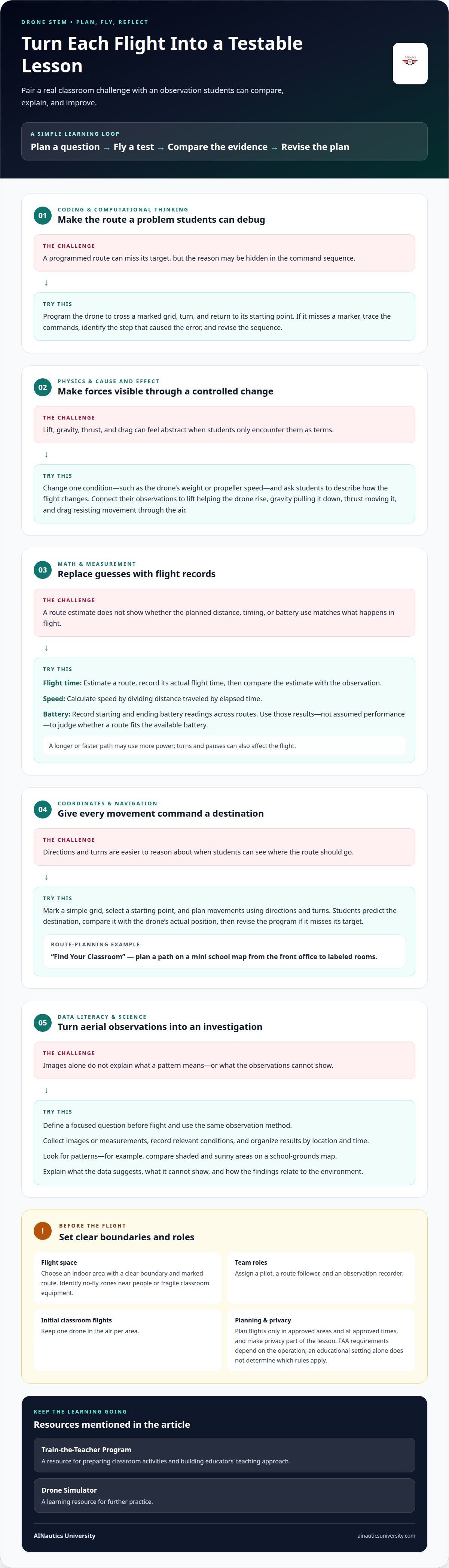
Coding challenges develop computational thinking: breaking a task into steps, spotting errors, and adjusting a plan. For example, students can program a drone to cross a marked grid, turn, and return to its starting point. If it misses a marker, they can trace the commands, identify the step that caused the error, and revise the sequence.
Aerial data projects add a complete investigation cycle. Students plan what to observe, collect images or measurements, organize the results, and look for patterns. A map of the school grounds, for example, can help a class compare shaded and sunny areas. Students can label observations, create a simple chart, and explain what the data suggests in its environmental context.
Environmental mapping makes observation more systematic. A drone can collect images of a garden or school grounds from above, giving students a consistent view for comparison. They might map tree locations or estimate tree heights using a suitable measurement method. The class can then discuss what the map reveals about vegetation and how the findings relate to the surrounding environment.
Science activities can use drone-collected observations to investigate a focused question. Students might compare plant growth in mapped areas or record visible changes around a school garden. They should define the question before flying, use the same observation method, and record relevant conditions. This structure helps distinguish measured evidence from guesses.
Remote data collection also changes how information reaches the classroom. A drone can gather images or readings away from students; after landing, the files can be transferred for review. Students can sort observations by location, label files, and compare them with field notes. This makes data handling part of the investigation, not an afterthought.
For a stronger analysis, ask students to connect each observation to a place and time. A map may show where a feature appears, while dated images can reveal whether it changes. Students can compare patterns, consider what their data cannot show, and explain their conclusions. These steps combine flight planning, spatial thinking, troubleshooting, and data literacy.
2. Applying math to flight time, battery life, and speed
Flight planning turns math into decisions students can test. Have learners estimate a route, record the drone’s actual flight time, and compare the results. They can calculate speed by dividing distance traveled by elapsed time. Comparing an estimate with an observation creates a useful lesson about measurement and assumptions.
Battery life adds another variable to the plan. Students can note the starting and ending battery readings, then compare them across routes. A longer or faster path may use more power, while turns and pauses can also affect the flight. Ask learners to use their recorded results, not assumed performance, when deciding whether a route fits the available battery.
Coordinates and angles make routes more precise. Mark a simple classroom grid, choose a starting point, and program movements using directions and turns. Students can predict where the drone should arrive, then compare that destination with its actual position. This connects geometry and spatial reasoning with coding and flight planning.
A mini school map can turn route planning into a navigation challenge. In a “Find Your Classroom” activity, students plan a path from the front office to labeled rooms. They can represent each movement on the grid, account for directional turns, and revise the program if the route misses its destination. The map gives every command a clear purpose.
What FAA rules apply to school drone flights? The educational setting alone doesn’t determine which FAA requirements apply; that depends on the operation. Plan flights only in approved areas and at approved times, and make privacy part of the lesson.
Choose an indoor flight space with a clear boundary and a marked route. Identify no-fly zones, such as areas near people or fragile classroom equipment, before launch. Assign practical roles: one student pilots, another follows the route, and a third records observations. For initial classroom flights, keep one drone in the air per area.
A naming activity can give an introductory flight a clear purpose. Students name the drone, create its backstory, then program a simple greeting such as a wave, spin, or hop. The sequence introduces takeoff, landing, movement commands, and block-based or text-based coding. Learners can predict the movement before flight and compare it with the result.
Close each flight with a short data review. Students can compare the planned route with the flown path, discuss timing, and revise one command. To prepare classroom activities and build educators’ teaching approach, explore the Train-the-Teacher Program.
3. Cross-curricular connections to math, science, art, and language
A drone project can connect subjects through one shared task. For example, students can map a school garden, calculate distances between planting beds, and describe the route. Math supports measurement, science frames questions about plant conditions, and mapping gives learners a visual record. The same activity develops observation and communication skills.
In science, students can plan an observation, gather drone images, and explain what those images show. A class might compare shaded and sunny garden areas, then identify what additional information would strengthen its explanation. The drone provides a viewpoint; students still need evidence, careful reasoning, and a clear account of their methods.
Art lessons can focus on composition and perspective. Students can examine how an aerial image changes when the drone follows a different route or uses a different viewpoint. They might create a labeled visual map or use selected images to tell a story about a familiar place. The creative task turns flight planning into a decision about what viewers notice.
Language arts can add a research and presentation goal. After mapping a campus feature, students can write a field report that separates observations from interpretations. They can also caption an image sequence, explain route choices, or present findings to classmates. These tasks strengthen precise vocabulary and make technical ideas accessible to an audience.
Cross-curricular lessons work best when each subject has a defined learning outcome. For a school-ground mapping project, set a math goal around scale or distance, a science goal around observation, and a writing goal around evidence-based explanation. Engaging STEM activities with drones can connect these objectives through one purposeful project while preserving each subject’s distinct learning goal.
How can teachers compare drone STEM curricula, kits, and simulators? Start with the intended grade range, learning goals, lesson sequence, educator preparation, and assessment approach. Then consider how each resource supports a specific classroom task, such as mapping a garden or explaining a flight route.
K-12 drone curriculum resources can support different levels of classroom experience, but a resource still needs to fit local teaching goals. Check whether its activities connect with the subjects being taught and whether students can show what they learned. A curriculum-mapped resource makes those connections clear through lesson objectives, activities, and evidence of learning.
Cost planning should account for the full classroom setup, not just a kit. Consider activity materials, access to required software, educator preparation, and how lessons fit into existing curriculum time. A mapping lesson using familiar school grounds, for example, may connect several subjects while keeping the project focused on available learning objectives.
For standards-aligned planning, begin with the skills students must demonstrate, then choose a drone activity that lets them practice and show those skills. Engaging STEM activities with drones can support this approach when the flight task serves specific objectives. A route-mapping task can combine measurement, spatial reasoning, and written explanation, keeping technology in service of learning.
4. Drone components and safety protocols
Before flight, teachers should introduce the drone’s components, explain how it works, and establish classroom safety rules. Identify the frame, propellers, motors, battery, controller, and camera. Students can match each part to its role, then trace how a pilot’s command becomes movement. This introduction gives learners shared language before they tackle an obstacle course or more complex activity.
Start with the controls and the drone’s visible parts. The controller sends the pilot’s commands, while the motors turn the propellers to move the aircraft. The battery supplies power, and a camera can capture images for a learning task. Ask students to identify each component on the classroom drone, then explain how it contributes to a planned flight.
Set clear boundaries before any activity. Mark the designated flight area, identify places the drone must avoid, and explain where students should stand during the exercise. Keep flights in approved areas and at approved times to respect privacy. A taped boundary around the practice space gives students a visible reference for keeping the activity within its planned limits.
What safety precautions should teachers follow for classroom drone activities? Introduce the drone’s parts and operation, establish clear rules and designated flight areas, and keep flights to approved places and times. Explain how privacy shapes the activity before students begin.
Make privacy part of the lesson plan, not an afterthought. If students are mapping a school garden, define the garden as the subject and focus image review on the assigned area. Discuss what an aerial image might reveal about people or private spaces. This helps students connect responsible data collection with respect for the school community.
Use a staged progression to build practical understanding. First, students identify components while the drone remains on the classroom table. Next, they review the flight boundary and explain the rules in their own words. Then they can move on to a simple, supervised flight task. Each stage gives teachers a chance to correct misunderstandings before adding a new challenge.
Obstacle courses can teach spatial awareness when they have clear limits. Arrange a simple route with open space between markers, and have students describe the path before flight. They can discuss where a turn occurs and which areas remain outside the route. The goal is careful planning and problem-solving, not speed or risky maneuvers.
Teachers can use a preflight discussion to connect components with decisions. Ask what the camera should capture, which areas are off-limits, and how students will follow the agreed route. These questions make safety, privacy, and ethics visible parts of drone education. Students practice habits that support responsible use of unmanned aircraft systems.
5. Hands-on drone flying activities
Hands-on flight gives students a concrete challenge to plan, test, and improve. For elementary students, try a simple greeting flight with a name and movement command. Middle school learners can follow a mini school map, while high school students can plan a route and explain its design. Adjust the task’s complexity, not its core purpose: connect each flight to a learning goal.
For an easy classroom activity, use a drone, floor space, and tape to mark a target. In a School Supply Drop challenge, students guide the drone to deliver a lightweight classroom item to a taped square, desk, or bin. They can take turns planning the approach, piloting, and recording whether the item reached its target.
Keep the first flight challenge simple. Ask students to take off, move toward a visible marker, and land in a chosen area. Keep one drone in the air per area during initial classroom flights. The rest of the class can follow the route on paper, record commands, or predict the next movement.
Students can build an obstacle course with classroom-safe markers, such as taped lines or open floor spaces. Have them draw the route first and mark turns and boundaries, then translate each movement into coding commands. After a flight, compare the planned path with the drone’s actual path and revise one command at a time.
For a more collaborative challenge, assign flight-crew roles: pilot, coder, engineer, navigator, and analyst. The coder prepares commands, the navigator follows the route, and the analyst records what happened. Rotate roles between attempts so students experience different parts of the task, from planning to review.
Aerial mapping can turn the school grounds into a shared investigation. Students can plan a route over an approved area, collect images, and create a map highlighting features such as trees or garden beds. Connect the flight to science through observation, math through route measurements, or art through image composition.
Another hands-on option is to change one flight condition and observe the result. Students can compare how a change in propeller speed or drone weight affects movement, then describe what they noticed. Keep the question focused, such as whether the drone follows the same route after the change. This comparison makes experimentation part of flying.
Make each activity end with evidence of learning. Students can sketch the route, list the commands, and describe one improvement for their next attempt. For practical flight preparation, explore guided drone learning resources that help students build confidence through structured practice.
AINautics University: Drone Simulator
AINautics University offers a Drone Simulator for learners building familiarity with drone concepts. It can complement classroom activities by giving students another way to explore flight before applying ideas in hands-on lessons. Educators developing classroom drone learning can also explore the Train-the-Teacher Program and VR Trailer Mobile Lab.
For learners preparing to explore commercial UAS careers, Part 107 Training provides a path to study certification topics. The right next step depends on your goal: classroom integration, structured flight learning, or certification preparation. Choose the resource that supports the work you want to do next.
Contact AINautics University to discuss which learning option fits your goals.
Build on the curiosity that takes flight
Let the next project begin with a question students genuinely want to answer. That focus can turn a classroom activity into a pathway for continued learning, whether students want to explore UAS careers, educators want to develop drone lessons, or future pilots want to prepare for certification. Engaging STEM activities with drones can be a starting point, not the finish line.
Choose a next step that matches your goal. AINautics University offers Part 107 Training for certification preparation, the Train-the-Teacher Program for educators, and the VR Trailer Mobile Lab as an educational resource. Each can support a different part of a learner’s or teacher’s development.
Keep asking questions, building skills, and connecting classroom learning with real-world possibilities. Contact AINautics University today to discuss your educational goals and next step. The next lesson could spark a lasting interest in aviation and technology.
Frequently Asked Questions
What science concepts can students learn through drone activities?
Drone projects help students practice forming hypotheses, identifying variables, and evaluating evidence. For example, they can predict how changing a route or flight condition may affect an observation, then compare their prediction with what happened. Students can also discuss how engineers balance design goals with constraints such as stability and control. These activities connect scientific reasoning with engineering design, encouraging learners to explain not only what they observed, but how they reached their conclusion.
What math and coding skills do drone STEM projects teach?
Students can develop logical sequencing, debugging, measurement, and proportional reasoning. A coding task might ask learners to make a command depend on a condition, such as continuing only after reaching a marked target. They can test the sequence, find where it fails, and revise the logic. Math extensions include comparing scale drawings with real spaces or organizing observations in tables. These skills support careful planning and clear explanations, even when students aren’t piloting.
What materials and equipment are needed for student drone projects?
Materials depend on whether the activity involves flight, planning, or simulation. A hands-on lesson may use a drone and controller, plus paper maps, pencils, and simple markers for route planning. A no-flight introduction can use printed grids and written movement commands to practice navigation logic. A drone simulator can provide another learning resource. Choose materials based on the lesson objective, available space, and the school’s established safety procedures.
Where can schools and youth groups find drone STEM resources and grants?
Schools can start with curriculum and professional-learning resources such as AINautics University’s Train-the-Teacher Program, VR Trailer Mobile Lab, and UAS Student Scholars program. These are educational offerings, not stated grant programs. For funding leads, ask a school or youth organization’s grants office about relevant STEM, career and technical education, or workforce-development opportunities. Local education foundations may also share funding notices. Match each application to a defined learning plan and the students it will serve.

Article by
AINautics University Team
The team behind AINautics University, dedicated to drone education and FAA Part 107 certification prep, VR flight simulation, and STEM training programs for students and educators.


