
The most dangerous part of a drone flight isn't a mechanical failure; it's an invisible line on a map you didn't know existed. For many new pilots and educators, the fear of accidentally wandering into restricted territory is a significant barrier to professional growth. Having drone airspace classes explained simply is the difference between a stressful afternoon and a successful mission. It's perfectly normal to feel confused by the overlapping circles and color-coded layers of a sectional chart. You want to ensure every flight is legal, safe, and professional.
This guide demystifies the National Airspace System by providing a clear, professional breakdown of FAA airspace classes. We'll cover the specific requirements for Classes A through G, giving you the tools to check your surroundings before every takeoff. Whether you are a student in our UAS Student Scholars program or an educator using the AINautics Drone Simulator to teach flight physics, mastering these tiers is essential. By the end of this article, you'll have the knowledge needed to pursue your Part 107 certification and operate with the authority of a seasoned pilot. Let's explore how these digital coordination zones keep our skies safe for everyone.
Key Takeaways
- Understand the structure of the National Airspace System and how the "upside-down wedding cake" model helps you visualize controlled zones.
- Get drone airspace classes explained with a clear breakdown of where you can fly freely and where you'll need prior authorization from the FAA.
- Master the essential skills for reading sectional charts and using LAANC to secure near-instant flight approvals in busy environments.
- Learn how specialized training like the AINautics Drone Simulator and Part 107 Training prepares you for high-level professional responsibilities.
- Explore how educators can use the Train-the-Teacher program to bring these critical safety standards into the classroom for the next generation of pilots.
Understanding the National Airspace System (NAS) in 2026
The National Airspace System (NAS) is a complex network of air routes, navigational aids, and regulatory boundaries. In 2026, it's no longer just a highway for commercial airliners and military jets. It is a shared ecosystem where Cessnas, emergency helicopters, and delivery drones operate side-by-side. To keep this massive system moving safely, the FAA relies on a US airspace classification system. This framework ensures every pilot knows exactly where they are allowed to be and who they need to coordinate with before takeoff. Having these drone airspace classes explained is the first step toward professional mastery for any aspiring pilot.
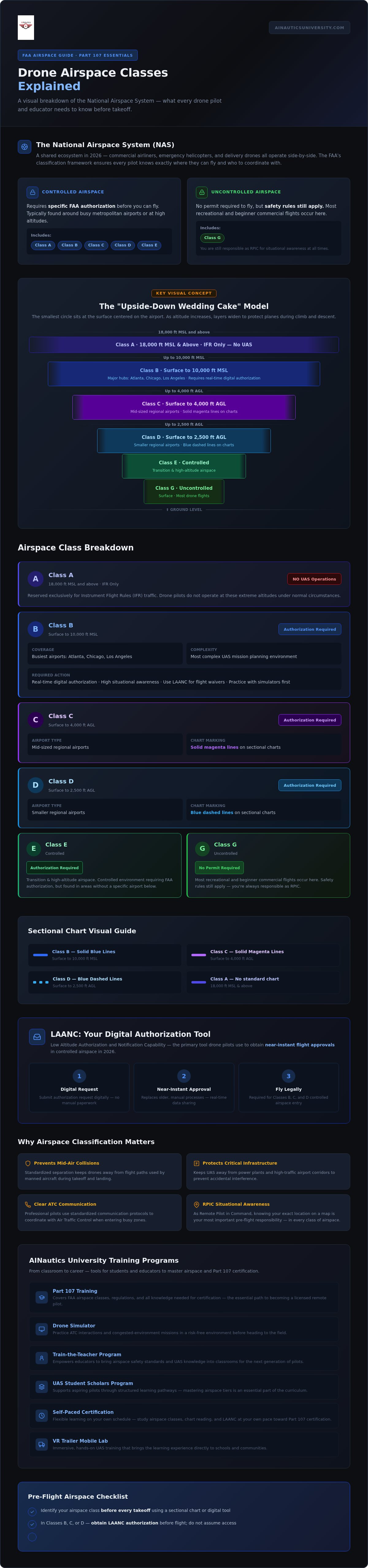
Visualizing this environment is easier if you think of an upside-down wedding cake. The smallest circle of the cake sits on the surface, centered on the airport. As you move higher into the sky, the layers become wider to protect planes as they climb or descend. This tiered structure is the foundation of our Part 107 drone training curriculum. As we move through 2026, the NAS is shifting toward a digital-first management style. Automated authorizations and real-time data sharing are replacing older, manual processes, making it more efficient for drone pilots to join the national grid.
Why Airspace Classes Matter for Safety
Safety is the primary driver of all FAA regulations. Standardized separation prevents mid-air collisions by keeping drones away from the specific flight paths used by manned aircraft. It also protects critical infrastructure like power plants and high-traffic airport corridors from accidental interference. Professional pilots use clear communication protocols to coordinate with Air Traffic Control (ATC) when entering busy zones. At AINautics University, we use our Drone Simulator to help students practice these interactions in a risk-free environment before they ever head to the field.
The Difference Between Controlled and Uncontrolled Airspace
Airspace is divided into two main categories: controlled and uncontrolled. Controlled airspace, which includes Classes B, C, D, and E, requires specific FAA authorization before you can fly. These areas are typically found around busy metropolitan airports or at high altitudes. In contrast, uncontrolled airspace is known as Class G. This is where most recreational and beginner commercial flights occur. While you don't need a permit to fly in Class G, you are still bound by safety rules. As the Remote Pilot in Command (RPIC), you're responsible for maintaining situational awareness at all times. Whether you're learning through our Self-Paced Certification or participating in the UAS Student Scholars program, knowing your exact location on a map is your most important responsibility.
The Alphabet of Airspace: Classes B, C, and D
Controlled airspace is categorized by the volume of traffic and the level of oversight provided by Air Traffic Control (ATC). For any pilot, having these drone airspace classes explained is vital for maintaining legal compliance. Classes B, C, and D represent the most active environments in the National Airspace System. These zones surround airports where manned aircraft are most likely to be at low altitudes during takeoff and landing. To enter these areas, drone pilots must obtain digital authorization, typically through the Low Altitude Authorization and Notification Capability (LAANC).
Class B: Navigating Major Metropolitan Hubs
Class B airspace surrounds the busiest airports in the country, such as those in Atlanta, Chicago, or Los Angeles. It usually extends from the surface up to 10,000 feet Mean Sea Level (MSL). Think of it as a multi-layered fortress designed to protect heavy commercial traffic. To operate here, you need real-time digital authorization and a high level of situational awareness. Class B is the most complex environment for UAS mission planning. Because of the density of aircraft, pilots often use tools like the AINautics Drone Simulator to practice missions in congested environments before applying for actual flight waivers.
Classes C and D: Regional and Local Airport Operations
Class C and Class D airspace serve mid-sized and smaller regional airports. Class C typically extends from the surface to 4,000 feet Above Ground Level (AGL) and is identified on sectional charts by solid magenta lines. Class D is smaller, reaching up to 2,500 feet AGL, and is marked by blue dashed lines. While these areas have less traffic than Class B hubs, they still require strict coordination. If an airport isn't LAANC-enabled, you may need to file a manual request through the FAA DroneZone portal well in advance of your flight.
Commercial missions in these zones often involve infrastructure inspections or real estate photography. Before you fly, it's a good idea to consult FAA Airspace 101 for drone pilots to refresh your understanding of these boundaries. Mastering these chart symbols is a core part of our professional training programs, ensuring you can identify every line and altitude limit with confidence. Whether you're inspecting a tower in Class D or filming a stadium near Class C, knowing the rules keeps your career on track and the skies safe for everyone.
Navigating the Common Ground: Class E and Class G
While the complex tiers of major airports get a lot of attention, the vast majority of drone missions occur in the space between. Understanding how these layers interact is vital for any pilot. When you have drone airspace classes explained in the context of daily operations, you realize that Class G and Class E are where your professional skills are tested most often. These areas aren't just empty space; they're active zones where general aviation and commercial drones must share the sky responsibly.
Class G: The Drone Pilot's Primary Workspace
Class G is uncontrolled airspace. It typically extends from the surface up to either 700 feet or 1,200 feet Above Ground Level (AGL). For most Part 107 operations, this is your primary office. You don't need ATC permission to fly here, but that doesn't mean there are no rules. Many non-towered airports exist within Class G. Pilots of crop dusters or small planes might be flying low, so your "See and Avoid" responsibility is paramount. You must always yield the right of way to manned aircraft. It's a fundamental safety habit we emphasize in our training.
The standard 400-foot AGL limit for drones serves as a vital safety buffer. By staying below 400 feet, you remain well below the floor of most manned aircraft traffic, even in uncontrolled zones. However, modern compliance is about more than just altitude. You must also follow FAA Remote ID requirements for drones to ensure your aircraft is digitally visible to other users of the NAS. This technology is a cornerstone of the 2026 airspace management strategy.
Class E: The Transitional Layer
Class E is controlled airspace, but it's often called "Everywhere Else." It fills the gaps between the other classes and usually starts at 1,200 feet AGL, though it can drop to 700 feet or even the surface near airports. Its main purpose is to protect aircraft flying under instrument flight rules (IFR), especially during their approach to a runway. While it is controlled, you generally don't need authorization to fly a drone in Class E unless it starts at the surface.
Identifying these variations on a sectional chart is a critical skill. On a map, a faded magenta vignette indicates Class E starts at 700 feet AGL. If the vignette is absent, it usually starts at 1,200 feet. In rare cases where a dashed magenta line surrounds an airport, Class E starts at the surface. In those specific surface-level zones, you must obtain authorization just like you would for Class B or C. Our UAS Student Scholars program focuses heavily on these chart-reading skills. We teach students to identify these subtle map markings so they can plan safe, legal missions in any environment.
Modern Tools for Airspace Awareness and Compliance
Operating in the National Airspace System requires more than just a certificate. You need a suite of digital and physical tools to maintain compliance. In 2026, the process is faster and more integrated than ever before. Having drone airspace classes explained is only the first step. You must now apply that knowledge using real-time data and sophisticated flight planning software. Using these tools ensures that having drone airspace classes explained translates into professional, safe flight habits in the field.
Reading sectional charts remains a fundamental skill for every pilot. These maps use specific colors and symbols to denote boundaries. For example, solid blue lines indicate Class B, while dashed blue lines signify Class D. Altitudes are typically listed in hundreds of feet Mean Sea Level (MSL). To practice identifying these complex layers without risking a violation, many students utilize the AINautics Drone Simulator. This immersive tool replicates real-world airspace, allowing you to master chart reading in a safe, virtual environment.
Digital Authorization (LAANC) Explained
The Low Altitude Authorization and Notification Capability (LAANC) has revolutionized how we access controlled skies. It bridges the communication gap between drone pilots and Air Traffic Control. By using an FAA-approved app, you can submit a flight plan and receive a response in seconds. Most requests result in "Automatic Approval" if they fall within pre-set altitude limits. If your mission requires a higher altitude or is in a sensitive zone, the system may flag it for "Further Coordination." This means a human controller will review your request. This process takes longer but allows for more complex operations.
The Vital Importance of Remote ID
By 2026, Remote ID is a non-negotiable standard for the industry. It functions as a digital license plate, broadcasting your drone's identity and location to nearby receivers. This technology enhances safety in congested airspace by allowing other pilots and authorities to identify UAS traffic in real-time. Whether you're flying for fun or operating under Part 107, compliance is mandatory for almost all aircraft. This layer of transparency is what allows the FAA to integrate more advanced missions, such as package delivery and infrastructure monitoring, into our daily lives.
Ready to master these tools and launch your career? Explore our comprehensive drone training programs today and start your journey toward certification.
Building Mastery: From Classroom to Career
Mastery of the National Airspace System is about more than passing a single exam. It is the technical foundation for high-level operations that define the modern industry. As the FAA moves toward Part 108 and Beyond Visual Line of Sight (BVLOS) missions, understanding how these zones interact becomes even more critical for safety. Having drone airspace classes explained in a classroom setting allows students to visualize the sky as a structured, professional environment rather than just open air. This specialized knowledge directly translates into high-paying future drone careers in sectors like medical logistics, public safety, and large-scale infrastructure management.
Empowering the Next Generation of Pilots
Integrating UAS education into STEM and Career and Technical Education (CTE) pathways provides a clear roadmap for the next generation. The UAS Student Scholars program is designed to build a professional workforce by encouraging students to pursue Part 107 certification while they are still in school. By providing drone airspace classes explained through hands-on tools like the VR Trailer Mobile Lab, we make abstract regulatory boundaries tangible for every learner. Students don't just read about Class B or Class D; they step into an immersive environment where they can see the "upside-down wedding cake" structure for themselves. This level of visualization builds a deep, intuitive understanding of safety that traditional textbooks simply cannot match.
Scaling Your Drone Program with AINautics University
For schools and districts, the challenge often lies in the logistics of implementation. Our Train-the-Teacher program equips educators with the specific knowledge and confidence needed to lead a high-standard UAS classroom. We simplify the complexities of federal compliance and curriculum development so teachers can focus on student engagement. Our "Launch a Drone Program in 90 Days" model provides a turnkey solution for institutions looking to modernize their offerings without the typical administrative delays. This structured approach ensures that every student has access to the same high-quality training used by industry professionals.
Career readiness in 2026 requires a commitment to continuous learning and technical specialization. Whether you are a student exploring future drone careers or an educator building a new program from the ground up, the right resources make all the difference. Our Self-Paced Certification options allow for flexible, comprehensive learning that fits into any academic or professional schedule. We are here to bridge the gap between current skills and the technological demands of the future. Don't wait for the industry to move past you. Start your journey with AINautics University today and take full command of your professional path.
Take Command of Your Professional Future
Mastering the National Airspace System is the first step toward a high-impact career in the drone industry. You've seen how the "upside-down wedding cake" model and digital tools like LAANC create a safe environment for all pilots. Having drone airspace classes explained provides the clarity you need to operate with confidence and legal compliance. Whether you're an educator launching a program or a student pursuing Part 107 certification, this knowledge is your most valuable asset.
AINautics University is committed to your success as a Service-Disabled Veteran-Owned Small Business and a proud member of AUVSI. We offer a 90-Day Implementation Guarantee for schools, ensuring your program takes flight without delay. From our immersive Drone Simulator to the VR Trailer Mobile Lab, we provide the specialized tools required for modern mastery. The future of aviation is digital, integrated, and full of opportunity. Don't wait to start your journey.
Frequently Asked Questions
Can I fly my drone in Class B airspace?
Yes, you can fly in Class B airspace, but you must obtain prior FAA authorization. Most pilots use LAANC to receive near-instant approval for flights within specific altitude grids. Operating in these busy metropolitan hubs requires a high level of situational awareness. Our Part 107 Training prepares you to handle these complex environments with professional precision. Always check for temporary flight restrictions before you power up your rotors.
What is the maximum altitude I can fly a drone in Class G?
In Class G, the maximum altitude for drone operations is 400 feet above ground level (AGL). This limit is a core part of having drone airspace classes explained to new pilots because it provides a safety buffer from manned aircraft. You can fly higher if you are within 400 feet of a structure, provided you stay within a 400-foot radius of that structure. Mastering these vertical boundaries is essential for legal flight.
How do I know what airspace class I am currently in?
Determining your current airspace requires checking a sectional chart or a mobile authorization app. Digital tools provide real-time data on your location and any surrounding controlled zones. For a deeper understanding, students in our UAS Student Scholars program practice identifying these boundaries on professional maps. You can also use the AINautics Drone Simulator to gain experience recognizing different airspace classes in a risk-free, virtual environment before heading out to the field.
Do I need a permit to fly in controlled airspace?
You must have FAA authorization to fly in controlled airspace, which includes Classes B, C, D, and E. This is not a "permit" in the traditional sense, but a digital approval linked to your pilot credentials. Having drone airspace classes explained clearly helps you understand why these approvals are necessary for safety. Our Self-Paced Certification options cover the exact steps for using LAANC apps to secure these authorizations quickly and legally.
What happens if I accidentally fly into restricted airspace?
Accidentally entering restricted airspace is a serious safety violation that can lead to FAA fines or the suspension of your pilot certificate. If you realize you've crossed a boundary, exit the area immediately and land your aircraft as soon as it's safe. Documentation is key. You should report the incident if required by regulations. Our training emphasizes pre-flight planning to ensure you never find yourself in this stressful and potentially costly situation.
Is Class A airspace relevant for drone pilots?
Class A airspace is generally not relevant for standard drone operations. It begins at 18,000 feet Mean Sea Level (MSL) and extends up to 60,000 feet. Since Part 107 pilots are limited to 400 feet AGL, you won't encounter Class A during normal commercial missions. However, understanding its existence is part of the comprehensive knowledge required for your certification. This ensures you respect the broader structure of the National Airspace System.
What is the difference between MSL and AGL in airspace charts?
MSL stands for Mean Sea Level, which measures altitude relative to the ocean's surface. AGL stands for Above Ground Level, measuring your height directly over the terrain. Sectional charts often use MSL to define the "ceiling" and "floor" of airspace layers, while drone regulations use AGL for the 400-foot flight limit. Distinguishing between these two is a critical skill we teach in our VR Trailer Mobile Lab to ensure total mission accuracy.
How has Remote ID changed airspace rules in 2026?
By 2026, Remote ID functions as a digital license plate for almost all drones in flight. It broadcasts your location and identification to authorities, enhancing safety in congested areas. This technology is a prerequisite for moving toward Part 108 rules and Beyond Visual Line of Sight (BVLOS) operations. Our Train-the-Teacher Program equips educators with the latest compliance standards to ensure their students are ready for this digital-first era of aviation.

Article by
AINautics University Team
The team behind AINautics University, dedicated to drone education and FAA Part 107 certification prep, VR flight simulation, and STEM training programs for students and educators.


