
Your drone's flight controller doesn't care what your altimeter says. It only cares about the actual density of the air molecules hitting its propellers. In 2026, air density remains the "silent killer" of UAS performance, causing unexpected crashes and shortened battery life for even the most advanced systems. You aren't alone if you find the math behind calculating density altitude for UAS a bit intimidating. Many learners in our UAS Student Scholars program initially struggle to distinguish between pressure altitude and the actual performance altitude of their aircraft.
It's frustrating when a drone feels sluggish or fails to maintain hover during a critical mission. We're going to clear up that confusion today. You'll learn exactly how to calculate these figures to protect your hardware and pass your Part 107 exam with total confidence. We'll explore the core formulas used in our Part 107 Training and show you how to use the AINautics Drone Simulator to experience these high-altitude effects safely. This guide provides the practical tools you need to master the skies and ensure every flight is a professional success.
Key Takeaways
- Grasp why density altitude is the true measure of your aircraft's performance by understanding how it differs from physical elevation.
- Master the specific formulas for calculating density altitude for UAS to ensure your mission planning remains accurate and safe in 2026.
- Identify the critical roles of temperature and barometric pressure in determining lift efficiency and motor cooling.
- Use immersive tools like the AINautics Drone Simulator to experience how thin air impacts flight handling without risking your hardware.
- Build a foundation for professional mastery that extends beyond basic Part 107 Training toward advanced commercial UAS operations.
What Is Density Altitude and Why Is It Critical for UAS?
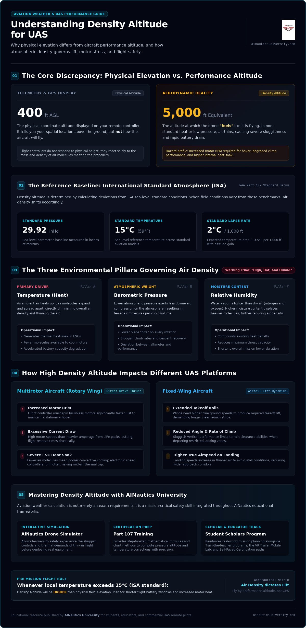
Your remote controller might show you are at 400 feet, but your drone might act like it is struggling at 5,000 feet. This discrepancy is the core of density altitude. We define it as the altitude at which the aircraft "feels" like it is flying based on the air density around it. While your GPS provides a physical location, density altitude dictates your actual performance. In the high-stakes environment of 2026, understanding this distinction is what separates a professional pilot from a hobbyist.
To understand this concept, we look at the International Standard Atmosphere (ISA). This is a mathematical baseline used by aviators worldwide. At sea level, standard conditions are 29.92 inches of mercury (Hg) and 15 degrees Celsius (15C). When conditions deviate from these standards, the air density changes, and so does your drone's ability to stay airborne. Calculating density altitude for UAS starts with comparing your current local weather against these ISA benchmarks.
The Concept of 'Thin Air' in UAS Operations
Think of air molecules as the "grip" for your propellers. Propellers are airfoils that generate lift by moving through these molecules. In dense air, there are more molecules for the blades to push against. As air becomes "thin" due to heat or low pressure, those molecules spread out. Fewer molecules mean less "bite" and less lift. Pilots often describe these hazardous conditions as "high, hot, and humid" because each factor reduces air density. Density altitude is the pressure altitude corrected for non-standard temperature variations. You can explore the underlying density altitude principles to see how these physics apply to all forms of aviation.
Why UAS Pilots Cannot Ignore Performance Altitude
Ignoring performance altitude leads to mission failure or hardware damage. For fixed-wing UAS, high density altitude results in longer takeoff rolls and sluggish climb rates. Multirotor pilots face a different challenge. To maintain a hover in thin air, the flight controller must spin the brushless motors significantly faster. This draws more current from the battery and generates excess heat in the electronic speed controllers (ESCs). Mastering the art of calculating density altitude for UAS allows you to predict these battery drains accurately.
Our Drone Training for Beginners guide emphasizes that weather mastery is a safety requirement, not an elective. Students in our UAS Student Scholars program use the AINautics Drone Simulator to practice these scenarios. By simulating "thin air" environments, they learn to recognize performance drops before they ever launch a real aircraft. This specialized knowledge is a cornerstone of our Part 107 Training, ensuring you're ready for the professional demands of 2026.
The Three Pillars of Air Density: Temperature, Pressure, and Humidity
Air density isn't a static number. It is the dynamic result of three environmental forces that dictate your drone's flight envelope. For professional pilots, calculating density altitude for UAS is the only way to visualize how these forces collide in the field. Temperature, pressure, and humidity create a performance ceiling you cannot ignore. If you fail to account for these variables, you risk overworking your motors or failing to clear obstacles on takeoff.
Temperature: The Primary Driver of DA
Temperature is the most volatile factor in the aviation weather equation. As air heats up, molecules expand and move further apart, which directly reduces the density of the air. The FAA Pilot's Handbook of Aeronautical Knowledge establishes that the standard temperature lapse rate is approximately 2°C (3.5°F) per 1,000 feet of elevation. When your local temperature is higher than the International Standard Atmosphere (ISA) baseline for your elevation, your drone performs as if it's at a much higher altitude.
This heat doesn't just steal lift; it attacks your hardware. High temperatures lead to "heat soak" in brushless motors and electronic speed controllers (ESCs). In thin air, there are fewer molecules to carry heat away from these components. Your flight controller must spin the motors faster to maintain altitude, generating more internal heat while the environment offers less cooling. This thermal stress can lead to mid-air failures or permanent battery degradation if not managed through proper mission planning.
Pressure and Humidity: The Invisible Variables
Pressure altitude is your starting point. It represents your height above the standard datum plane of 29.92 inches of mercury (Hg). When barometric pressure is low, the air is less compressed and therefore less dense. This mimics high-elevation conditions even if you're flying at sea level. Finding your pressure altitude is a critical first step in calculating density altitude for UAS. You can quickly find the current altimeter setting through local METAR reports or digital flight planning tools.
Humidity is often the most misunderstood pillar. Many beginners believe humid air is "heavy" and dense. It's actually the opposite. Water vapor molecules are lighter than the nitrogen and oxygen molecules they displace in the atmosphere. When humidity is high, the air becomes less dense, which further reduces the "bite" your propellers can get. While humidity has a smaller impact than temperature, it can be the tipping point that pushes a drone past its maximum takeoff weight (MTOW) efficiency in 2026's demanding commercial missions.
Mastering these three pillars ensures you never launch into a situation your aircraft can't handle. Our Part 107 Training provides the framework to analyze these weather data points with professional precision. By understanding the science of air density, you move beyond basic certification and into true operational mastery.
Step-by-Step: Calculating Density Altitude for Your UAS Mission
Mastering the math behind your flight is the hallmark of a professional pilot. While modern flight apps provide quick numbers, calculating density altitude for UAS manually ensures you understand the "why" behind your aircraft's performance. This process requires three specific data points: your field elevation, the current altimeter setting, and the outside air temperature (OAT). By following a structured approach, you can transform raw weather data into actionable mission limits.
Phase 1: Finding Your Pressure Altitude
Pressure altitude is the foundation of all performance calculations. It represents your height relative to the standard datum plane of 29.92 inches of mercury (Hg). To find it, use this formula: (Standard Pressure - Current Altimeter Setting) x 1,000 + Field Elevation. This step is vital because it accounts for how "heavy" or "light" the air is based on barometric pressure alone. You can find detailed explanations of these atmospheric baselines in the FAA Pilot's Handbook of Aeronautical Knowledge.
Imagine you are preparing for a mission at a field with an elevation of 500 feet. The local METAR reports an altimeter setting of 29.82 Hg. First, subtract 29.82 from 29.92 to get 0.10. Multiply 0.10 by 1,000 to get 100 feet. Finally, add that 100 feet to your 500-foot field elevation. Your pressure altitude is 600 feet. This tells you that even though you're physically at 500 feet, the low pressure makes your drone perform as if it's 100 feet higher.
Phase 2: The Density Altitude Formula
Once you have your pressure altitude, you must correct it for temperature. The standard formula is: Density Altitude = Pressure Altitude + [120 x (OAT in Celsius - ISA Temperature in Celsius)]. To find the ISA (Standard) temperature for your elevation, start with 15°C and subtract 2°C for every 1,000 feet of elevation. If you're at 2,000 feet, your standard temperature is 11°C.
Let's look at a worked example for a hot summer day. If your pressure altitude is 2,000 feet and the OAT is 90°F (approximately 32°C), your correction is significant. Subtract the standard 11°C from the actual 32°C to get a 21-degree deviation. Multiply 21 by 120 to get 2,520 feet. Add this to your 2,000-foot pressure altitude for a final density altitude of 4,520 feet. Your drone is now fighting the physics of an altitude more than double its physical location.
The 'Rule of Thumb' for Quick Field Estimation
In the field, you might not always have a calculator handy. The "120-foot rule" is a reliable mental shortcut: for every 1°C the temperature is above standard, your density altitude increases by 120 feet. This estimation is excellent for quick risk assessments during Part 107 drone training exercises. However, professional commercial missions in 2026 require documented, precise calculations to ensure safety margins. We encourage our UAS Student Scholars to validate these mental checks against a digital E6B or the AINautics Drone Simulator to see how these numbers translate into actual stick feel and battery endurance.
How High Density Altitude Affects UAS Performance and Safety
Many hobbyists mistakenly believe that density altitude is a concept reserved for manned aviation. In reality, it is a critical performance metric for every professional remote pilot in 2026. When you are calculating density altitude for UAS, you are essentially determining how much "grip" your propellers will have. In thin air, the airfoils must work harder to generate lift. This physical reality triggers a chain reaction across your drone's propulsion system, affecting everything from flight stability to component lifespan.
Aerodynamic efficiency drops sharply as air density decreases. Because there are fewer molecules for the propellers to displace, the aircraft's flight controller must increase motor RPM to maintain a steady hover. This isn't just a minor adjustment. It requires significantly more power. Additionally, the thinner air provides less resistance for sensors, which can sometimes lead to increased vibrations or "toilet bowling" effects where the GPS-stabilized drone begins to drift in circular patterns.
The Impact on Power Consumption and Flight Time
High density altitude is a thief of mission endurance. As motors spin faster to compensate for low air density, they demand a higher continuous amp draw from the battery. This leads to exponential battery drain. A mission that usually takes 20 minutes might be cut down to 14 minutes in high-DA conditions. Practicing these scenarios in the AINautics Drone Simulator is the best way to develop the muscle memory needed to handle a sluggish aircraft. It allows you to feel the reduced thrust and increased battery sag in a risk-free digital environment before you launch into a high-stakes commercial operation.
Structural and Safety Risks
The safety risks of high density altitude go beyond just shorter flight times. One of the most dangerous effects is the loss of "braking" capability. In dense air, a drone can stop or change direction quickly. In thin air, the aircraft carries more momentum and has less aerodynamic resistance to help it slow down. This can lead to collisions if a pilot isn't prepared for the increased stopping distance.
There is also a severe risk of Electronic Speed Controller (ESC) failure. ESCs generate significant heat, and they rely on the airflow from the propellers to stay cool. In high-DA environments, the air is both thinner and often hotter, making it an inefficient coolant. If you don't adjust your mission parameters, you risk a mid-air power failure. Use this checklist for high-DA mission planning:
- Reduce Payload: Remove unnecessary sensors or accessories to lower the required lift.
- Monitor Telemetry: Keep a close eye on battery temperature and voltage sag.
- Increase Safety Buffers: Land with 40% battery remaining instead of the usual 25%.
- Plan for Extra Batteries: Assume you will need 30% more power cycles to complete the same task.
Understanding these risks is a core component of professional mastery. If you're ready to move from basic flight to advanced operational safety, explore our Part 107 Training to build your career on a foundation of expert knowledge.
Elevating Your Expertise: UAS Weather Mastery with AINautics University
Calculating density altitude for UAS is a technical requirement for the FAA exam, but it is also the foundation of a professional career. In 2026, the industry demands pilots who don't just memorize formulas but deeply understand the physical limits of their aircraft. Passing the Part 107 test is only your first milestone. True mastery requires a commitment to ongoing education and a workforce-ready mindset that prioritizes operational safety above all else.
We believe that specialized knowledge is the bridge between a hobbyist and a high-earning UAS professional. While some programs focus solely on test preparation, we emphasize the practical application of aviation weather. This approach ensures that when you encounter "high, hot, and humid" conditions in the field, you have the confidence to make the right command decisions. Our curriculum is designed to empower individuals at every stage of their journey, from high school students to seasoned educators.
Immersive Learning with Simulators and VR
Traditional classroom settings often fail to convey the physical stress of managing a sluggish drone in thin air. We bridge this gap through Immersive Drone Training Technology. Our Drone Simulator allows students to feel the reduced thrust and increased battery drain of high-DA environments without risking expensive hardware. This hands-on experience is critical for developing the muscle memory needed for safe commercial operations.
For school districts and enterprise partners, our VR Trailer Mobile Lab brings this advanced training directly to your location. It provides a scenario-based environment where learners can practice emergency procedures and performance calculations in real-time. For busy professionals, our Self-Paced Certification options offer the flexibility to master these complex topics on your own schedule without sacrificing the depth of a formal aviation education.
Join the Next Generation of UAS Professionals
Building a robust UAS workforce starts with early engagement. Our UAS Scholarship for High School Students provides a clear pathway for youth to enter the industry with commercially viable skills. We also empower educators through our Train-the-Teacher program. This initiative ensures that STEM instructors have the tools and curriculum necessary to teach advanced concepts like air density and regulatory compliance to the next generation of scholars.
Whether you are an educator looking to expand your CTE offerings or a student ready to launch a career, the UAS Student Scholars program offers comprehensive preparation for the modern workforce. Mastering the art of calculating density altitude for UAS is just the beginning. Enroll in our Part 107 Training today to gain the specialized knowledge that will define your professional future in the skies.
Charting Your Professional Course in 2026
Understanding the physics of the atmosphere is what separates a certified remote pilot from a true aviation professional. By mastering the art of calculating density altitude for UAS, you protect your hardware and ensure every mission is conducted with a massive safety margin. You've learned how temperature and pressure dictate your drone's performance ceiling and how to use precise formulas to predict battery life and lift efficiency. These skills are essential for navigating the complex operational demands of the modern National Airspace System.
Your journey toward mastery shouldn't end with a single calculation. As an AUVSI industry member and SDVOSB certified institution, AINautics University is dedicated to your long-term success. Our mission-driven STEM curriculum provides the deep technical knowledge required for the high-stakes commercial landscape of 2026. Whether you are a student scholar or a career-changer, we provide the specialized training to help you thrive.
Enroll in Professional Part 107 Training at AINautics University today to join a community of experts committed to excellence. The future of flight is waiting; let's master it together.
Frequently Asked Questions
What is the simplest way to calculate density altitude without a calculator?
The 120-foot rule is the most efficient mental shortcut for calculating density altitude for UAS in the field. You start with your pressure altitude and add 120 feet for every degree Celsius that the outside air temperature exceeds the standard temperature for your elevation. While this provides a quick estimate for risk assessment, professional missions in 2026 require precise documentation. We recommend using the AINautics Drone Simulator to see how these estimates impact aircraft handling.
Does humidity really affect drone flight performance?
Humidity definitely impacts flight performance, though it's often overshadowed by temperature. Moist air is actually less dense than dry air because water vapor molecules are lighter than the nitrogen and oxygen they displace. This reduces the "bite" your propellers get, forcing motors to work harder. Our Part 107 Training covers these nuances in detail, ensuring you understand why "heavy" humid air is a common aviation myth that can compromise your mission safety.
How much does density altitude change with temperature?
Temperature is the most influential variable in the air density equation. According to standard aviation data, air density decreases by approximately 3% to 3.5% for every 10°F increase above standard temperature. This shift significantly reduces lift and thrust efficiency. Mastering these calculations is a core part of our UAS Student Scholars program, where learners practice predicting performance drops before they ever step onto a flight line for real-world commercial operations.
Is density altitude tested on the FAA Part 107 exam?
Density altitude is a mandatory topic on the FAA Part 107 Knowledge Exam as of 2026. It is formally assessed under the Weather Information section, specifically Knowledge Code UA.III.B.K1b. You'll need to demonstrate your ability to interpret density altitude charts or perform manual calculations to pass. Our Self-Paced Certification options provide targeted modules on this subject, helping you build the confidence needed to answer these technical weather questions accurately on your first attempt.
Can high density altitude cause my drone to crash?
High density altitude is a frequent contributor to UAS accidents. When the air is thin, your drone may not have enough thrust to clear an obstacle or recover from a rapid descent. Additionally, the increased workload on the motors can lead to an Electronic Speed Controller failure due to overheating. Proper mission planning and calculating density altitude for UAS are your best defenses against these performance-related crashes during hot or high-elevation flights.
Why does my drone battery drain faster on hot days?
Battery endurance drops on hot days because the flight controller must spin the motors at higher RPMs to maintain hover in thin air. This creates a higher continuous amp draw. Research indicates that LiPo batteries can see a 15% to 30% reduction in mission time under these conditions. Our VR Trailer Mobile Lab allows students to experience this rapid power depletion firsthand, teaching them to adjust return-to-home buffers for safe recovery.
What is the 'standard temperature' at sea level for ISA?
The International Standard Atmosphere baseline for temperature at sea level is exactly 15°C, which is 59°F. This serves as the starting point for all aviation performance calculations. As you gain elevation, this standard temperature decreases by roughly 2°C for every 1,000 feet. Understanding this baseline is crucial for educators in our Train-the-Teacher Program, as it allows them to explain atmospheric physics to their students using the same standards used by commercial airline pilots.
How do I find the current altimeter setting for my flight location?
You can find the current altimeter setting by reviewing the latest METAR from the nearest airport. Professional pilots also use digital flight planning tools and onboard telemetry sensors to stay updated. This setting represents the local barometric pressure adjusted to sea level. In 2026, real-time micro-weather data is becoming standard for enterprise missions, allowing for more precise calculations than standard airport reports can provide in remote areas.

Article by
AINautics University Team
The team behind AINautics University, dedicated to drone education and FAA Part 107 certification prep, VR flight simulation, and STEM training programs for students and educators.


